
If you find errors OR have additional information about this site, please send a message to contact@waynehistorians.org.
St. Peter Shipwreck (1898)
| Historic Site #: | 14-002 (Exists) Type: A1,B4,I0 | Town: | Williamson | ||
| Site Name: | St. Peter Shipwreck (1898) | GPS Coordinates: | 43.281709, -77.169514 | ||
| Address: | 4481 Lake Rd. Williamson NY | ||||
| Description: | |||||
See display and video at Williamson Pultneyville Historical Society, 4130 Mill Street, Hamlet of Pultneyville, NY The interpretive panel is in Pultneyville, New York, in Wayne County. The interpretive panel can be reached from Foreman Park 0.1 miles north of Lake Road. Marker is within B. Foreman Park. It is just off the northwest corner of the parking lot. It is one of 3 markers clustered together. | |||||
 |
.jpg) |
| Interpretive Panel | Wikipedia St. Peter under Tow |
| Historic narrative: | |||||
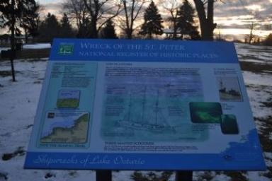
Inscription: The St. Peter left Oswego, New York carrying a full load of coal, headed for the safety of the Welland Canal when a storm struck her with 70 mph winds. Unable to reach the canal, the ship was turned back east to run before the wind, but the crew�s fight during 12 long hours of darkness, 20-foot high seas, gale-force winds, and freezing sleet was in vain. The ship, crew, and the Captain's wife were lost. The Captain was rescued by a boat from the local Lifesaving Service. Three-masted Schooner The St. Peter was a wooden hulled, schooner with three masts, built in 1873 by Edwards in Toledo, Ohio. She was 136' long, 26' wide, and 12� deep, with a gross weight of 290 tons. She was lost 5 miles NW of Sodus, NY on October ,27, 1898. Eight people were lost, including the crew and the Captain's wife. St. Peter Afloat The historic photo below shows the St. Peter being towed into harbor by a tug. After she sank, the masts still protruded from the water, but were later dropped to prevent hazards to navigation. The St. Peter, a 136-foot, three-masted  By Yugoboy, March 24, 2013 2. Entrance to B. Foreman Park as seen driving West on Lake Rd. Ships like the St. Peter were employed to carry coal and other bulk items between Great Lakes ports. The upright deck of the St. Peter is shown in the photo above, and a diver floats in front of her bow, right. Dive Site Information Location: East of Pultneyville, NY Access: Boat Only Depth: 117 feet Visibility: 20 to 100 feet. Average 45 feet. Temperature: 40 to 73 degrees F. Skill Level: Advanced open water diver. Bottom: Flat and silty. Hazards: Lake Ontario weather is unpredictable and can change very rapidly from good to severe. Weather conditions and unexpected weather changes should be a constant consideration. Strong currents may be present if sea Erected by Seaway Trail Inc. To read about this marker and other nearby markers: | |||||
Historical Marker Database
Wikipedia for St. Peter wreck
Lake Shore News Article 11/3/1898 about St. Peter wreck.