
If you find errors OR have additional information about this site, please send a message to contact@waynehistorians.org.
Palmyra Area Historic Marker
| Historic Site #: | 09-102 (Gone) Type: B4 | Town: | Palmyra | ||
| Site Name: | Palmyra Area Historic Marker | GPS Coordinates: | 43.065487, -77.180493 | ||
| Address: | 4190 Rt. 31 Palmyra NY | ||||
| Description: | |||||
| Marker is in Palmyra, New York, in Wayne County. Marker is at the intersection of Palmyra-Newark Road (New York State Route 31) and Galloway Road, on the right when traveling west on Palmyra-Newark Road. It is at an intersection, but it's set a little back from the road on the far side of New York's ugliest official parking area. | |||||
 |
| Historical Marker Database |
| Historic narrative: | |||||
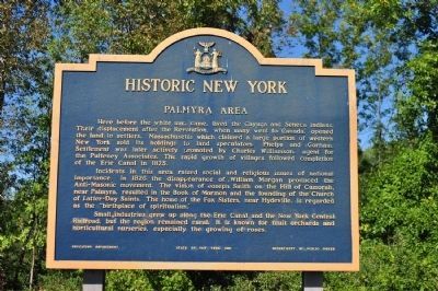
| Inscription: Here before the white man came, lived the Cayuga and Seneca Indians. Their displacement after the Revolution, when many went to Canada, opened the land to settlers. Massachusetts which claimed a large portion of western New York sold its holdings to land speculators, Phelps and Gorham. Settlement was later actively promoted by Charles Williamson, agent for the Pulteney Associates. The rapid growth of villages followed completion of the Erie Canal in 1825. Incidents in this area raised social and religious issues of national importance. In 1826 the disappearance of William Morgan produced the Anti-Masonic movement. The vision of Joseph Smith on the Hill of Cumorah, near Palmyra, resulted in the Book of Mormon and the founding of the Church of Latter-Day Saints. The home of the Fox Sisters, near Hydeville, is regarded as the "birthplace of spiritualism." Small industries grew up along the Erie Canal and the New York Central Railroad, but the region remained rural. It is known for fruit orchards and horticultural nurseries, especially the growing of roses. Erected 1961 by State Education Department. To read about this historical marker and other nearby markers: | |||||
Historical Marker Database